Good Evening and Happy Holidays
The weather lately has been pretty boring unless you like rain (It's certainly not my cup of tea) if you are a regualr reader of this blog you have probably heard me speak of a pattern change to more winter like conditions in several different posts and each time they never seem to stick and that has been due to the lack of blocking signals.
The pattern of late has been one of a "here today and gone tomorrow" type but several well trusted models are in general agreement that this is gonna change abrubtly in the new year. Blocking signals are starting to show up strongly in the NAO and PNA regions....lets not confuse the 500mb signals with the teleconnection signals because they are two different signals and dont always support each other. I expect a strong cold front near New Years that will be transported by what looks to be a clipper type system and if enough cold air is already in place we might get to witness one of those rare snow squall lines that set up along the cold front of some clippers during favorable conditions.
Several forecasters originally called for a cold winter but several of the same long range forecasters have since changed their tune to more of a warmer winter. Not me...im sticking with my guns and I fully expect the pattern change to happen around New Years. The AO has been off the charts positive for nearly two months and that is about as long as that usually happens so our saving grace is that it went positive early in fall and now has nowhere to go but to more neutral or negative values.
Toot
Friday, December 23, 2011
Monday, December 19, 2011
Winter Cancel? What?
Im growing tired of the cancel winter calls I am hearing...meteorological winter so far has not been a torch by any means...its been near normal to slightly above tempwise so far this December... Calendar winter has not even started yet and yeah that does have meaning..it's called winter solstice. With that said.... long periods of a tanking AO and a NAO block are not the normal December conditions here either... no matter how bad you may want to see those conditions...Wild swings in temps and patterns are more normal at this lattitude during the period of seasonal change from fall to winter.
Now I realize that people (including me) were expecting the neg NAO/AO to happen in December and it hasn't but it seems people have been spoiled by the last two winters and somehow think that cold and snowy is the normal pattern in December...its not!! People seem to forget that this is the southeastern united states and most unelevated places around here only average one or two days of an inch or more of snowfall during winter. Just remember there has already been two snow events already in the south even though they might have not been in your backyard.
Anybody making such broad statements as "cancel winter weather in so and so month" is completely wacko..I dont care who they are or what forum they post on. Nobody can make such a broad statement like that with ANY accuracy. If they cancelled winter weather for the months of November and December they are already wrong for parts of the mid-south... as they have already had two winter events no matter how long it may have stayed on the ground.
When there is not much confidence in any guidance it's pretty hard to argue with January climatology (which would be our snowiest month) especially if your basing your argument on relatively new teleconnect indices in the long range. People seem to think its allright to trust forcasted teleconnections in the long range but not model graphics when neither is very accurate for some reason. So no thanks...I will stick with climatology at this point
Wednesday, December 14, 2011
Rumors of Christmas snow
Good evening
Its been a beautiful day today with highs in the 60's to near 70 in some locations and it felt great...but I like to think of this as the calm before the storm. Mid to late December is climatalogically a favorable time for cold and snow around here and when it gets this warm in December you know big changes are coming. There are rumors flying around of some possible snow around Christmas and thats just what they are at this point..rumors!! With that said the pattern is starting to look more favorable after Dec 20th and it is possible that a major pattern changing storm will occur with possible severe wx. I am talking about the storm around the 20th...
I think a STRONG lakes cutter with possible severe wx along a nice cold front that it will eventually push into the gulf of mexico around the 20th where another low pressure system MAY form along that boundary and ride up it in a path similar to a Miller A...of course this will need great timing and all but the possibility seems to be there. These two systems may be enough to dislodge the PV feature from eastern Canada and Greenalnd long enough where higher heights would then be able to form and in theory high lattitude blocking could then initiate in the NAO region near the new year. At least thats my take on the long range ensembles and teleconnections and any help from the PNA might speed this process up.
Sunday, December 11, 2011
Importance of the Polar Vortex
Good afternoon
Most of the time on sundays I find myself wanting to research or write about a related aspect of the current pattern and today is no different.
Since there is a buzz going around about a possible stratospheric warming event I thought i would write about the relationship between the Arctic Oscillation...North Atlantic Oscillation and the Polar Vortex. These features are very important regarding sudden stratospheric warming and the Polar Vortex is the engine that drives NAO/AO. The polar vortex and the AO/NAO are directly related to each other and a general rule of thumb is a strong Polar Vortex equals a positive AO/NAO and a weak Polar Vortex equals a negative AO/NAO. A negative Arctic Oscillation (weakPV) generally means colder temperatures in the eastern United States during Boreal winter and a Positive Arctic Oscillation (Strong PV) generally means warmer temperatures in the eastern United States during boreal winter.
A strong Polar Vortex tends to be more concentated near the pole and circular in shape... it will generally keep the cold air bottled up near the polar regions (as seen in the past 60 days)... but a weaker Polar Vortex will become less concentrated near the polar regions and will become elongated and may even split into several smaller vorticies (as seen in the current pattern)...these smaller vorticies tend to move away fron the polar region and this allows higher pressures to settle in near the polar and arctic regions (yet to be seen). As higher pressures take hold near the pole... lower pressures and Arctic air are transported southward via the smaller vorticies that once were a strong polar vortex.
Strong Polar Vortex

Weak Polar Vortex

There is also a direct relationship between the AO and the NAO due to the NAO being measured in close vicinity to the Arctic region. When stratospheric warming occurs lower pressures are generally replaced with higher pressures in the Arctic regions. This usually means some type of blocking occurs in the high lattitudes of the NAO region due to these higher pressures. When this blocking pattern occurs the colder temperatures of the Arctic are forced southward into the eastern United States by a buckle in the jet stream caused by this blocking pattern that is the negative NAO/AO.
To illustrate just how related the NAO and AO are.. here is a graph showing the fall readings of the AO and NAO indicies. Notice how they behave in a very similar fashion to each other

Hopefully this little writeup will help somebody get a better understanding of how the Polar Vortex is the most important feature regarding a cold and snowy pattern here in the eastern United States. I have been watching this feature becoming weaker and displaced here on our side of the globe lately... this and the recent changes in modeling of the AO indice is a VERY good sign that the NAO/AO could be headed to a more conducive value for us winter wx lovers this season... only time will tell.
Friday, December 9, 2011
Persistent Polar Vortex
Good evening.. its December and it sure feels like it outside also. As long as the circumpolar vortex is positioned over northeastern North America its going to be seaonably to unseasonably cold over the eastern US overall. Any forecast that tells you there will be longterm warm spells including teleconnections and/or model graphics should be taken very lightly and with a huge grain of salt. This feature is currently controlling our weather and doesnt look to let up anytime soon.
GFS at Day 8

Thursday, December 8, 2011
Is Winter Over?
I wanted to talk a little about the pattern of the last 45-50 days. The fall/winter pattern that has developed is very unusual and is not behaving in any form or fashion the way it should. During October you had a raging negative PNA which in theory should have torched us...but we come out tempwise well below normal for that month. During the month of November the NAO and AO went positive... but the southeast managed to score an anomalous snow storm in November.
The Arctic oscillation (AO) is raging positive and at near record levels...but as you can feel it's still decently cold outside. On top of all that we are in a La Nina ENSO state... but yet there is a very active and visible El Nino like subtropical Jet stream. Despite La Nina conditions that say we should be warm and dry... we have actually been more cold and wet. We have been able to stay near or below normal despite unfavorable teleconnection indices and a pesky little southeast ridge..also there seems to be an abundance of strong cutoff lows this fall/winter.
Those that say winter is in trouble are totally looking way too much at numbers and teleconnection indices. They're not taking synoptics and verified data into account. As we get closer to a more climatalogical favored time period for winter weather... I see no reason why there wont be nice winter events with plenty of cold air. This fall/winter so far has been very wet compared to most and there has already been two snow events pretty far south for this time of year. We're getting closer to the real winter season here and when we have a nice arctic airmass in place I can totally see one of those big bowling ball cutoff lows dumping snow in a very widespread fashion despite a positive AO/NAO if that is still the case.
Our winter will happen...it's just not going to happen the way we have gotten used to it happening the last two years.
Tuesday, December 6, 2011

Saturday, December 3, 2011
Pattern Starting To Look Very Active
Good Evening
Im becoming very interested in the pattern. The timeframe around the Dec10-Dec20 is so close to being something nice...with the ridge off the east coast blocking the frontal systems from exiting the area and the arctic air piling up behind the front....it sets up a very nice baroclinc zone for many waves of low pressure to ride up.

Im starting to think someone gets a nice surprise. This stalled out boundary may hang around our backyards for several days and the snow chances will be on the rise with this setup. Im not ready to call for accumulating snow just yet...but it sure seems to be trending that way. Would like to see more model runs before totally coming on board but its a very conducive setup that will probably send the NAO and AO into a freefall
Im becoming very interested in the pattern. The timeframe around the Dec10-Dec20 is so close to being something nice...with the ridge off the east coast blocking the frontal systems from exiting the area and the arctic air piling up behind the front....it sets up a very nice baroclinc zone for many waves of low pressure to ride up.
Im starting to think someone gets a nice surprise. This stalled out boundary may hang around our backyards for several days and the snow chances will be on the rise with this setup. Im not ready to call for accumulating snow just yet...but it sure seems to be trending that way. Would like to see more model runs before totally coming on board but its a very conducive setup that will probably send the NAO and AO into a freefall
Arctic Air Set To Invade The SE
Good Morning
Well it seems the Euro was onto something a few days back and the polar vortex will drop into the northern states to say hello and it will push frigid air all the way into the south around the 10th of the month. There may be a few snow showers that accompany this cold front but that is yet to be determined.
This will set the table for a possible widespread winter type system in the east. Temps will be as much as 20 degrees below normal in some areas. So bundle up
Toot
Thursday, December 1, 2011
Weekend Stalling Frontal System
Good Evening
Another system near the weekend is starting to get a little interesting but in reality it will likely not produce any snow except for the higher elevations. A cold front will stall across the region with an area of low pressure forming near the SE that will ride up that frontal boundary producing some moderate rains and mountain snow.
If that LPS is a little stronger than modeled it would be possible for some valley snow but i'm seeing pretty good model agreement that argues against any snow in the valley. After this system the pattern is starting to look a little better for cold and snow.
The middle of December holds nice potential for some type of widespread winter event in the east IMO.
Toot
Wednesday, November 30, 2011
Bye Bye SE Ridge ? Hello -NAO?
Good Evening
After taking the evening look at model data...I have seen something different than the cool-warm-cool signal that has been dominate for the past 45 days. Alot of the models are trying to move the intermittent SE ridge to more of a intermittent Bermuda type ridge. If this happens troughs will be able to dig further into the southeastern united states and maybe into south florida.
This happenes alot when you see a -NAO/-QBO regime start to take hold of the pattern. We have been lacking in the -NAO department as I truly thought it would have taken hold by now....but that has not been the case. Time will tell and we will see if this is just another confusing aspect or if it is indeed a true signal for sustained cold.
Euro Showing Arctic Outbreak
The euro model has recently started picking up on a real mccoy Arctic outbreak...it's still out in the long range but it is something to keep an eye on

Reply To Snowman At TN WX
Snowman said
"So this is really a subjective point of view for everyone. Accumulation could mean different things for different people."
My response
NO I'm sorry Snowman that is totally false....you or anyone else cannot decide what accumulation means....that word already has a definition and there is no time restsraint on it. If snow accumulates on the ground that is accumulation...THIS IS NOT ROCKET SCIENCE.
Tuesday, November 29, 2011
Response to Bugalou at TN WX forum
Bugalou said
"This went pretty much how I thought it would, and overall, the high rates were able to pile up some snow in some areas, but all of this snow quickly melted down to generally a 1" or less slush, and in some cases completely gone. I am certainly not trying to toot my own horn, so I hope no one takes it like that, but this seems to prove that with warm ground temps (50-60 degree range) combined with marginal boundary layer temps, significant accumulations just cannot occur. Some may argue that accumulations around 3"-4" or so did occur in isolated areas, but when they last less than an hour, it is just hard to be happy with that (I need to make a dang snow man people!)"
My response
Well that's where you are COMPLETELY and totally wrong and deep down inside.... you know it.
It went nothing like how you thought it would....Significant accumulations (3" or more) did occur in several places..but yet you and Kevin refused to accept that those results could possibly happen and continued to downplay the situation. And now you want to try an claim some false victory and not eat any crow? Whatever dude..lmao
You need to eat your crow like a man...but I know you and your clique will refuse to do so and carry on like the weenies that y'all are. LMAO
Monday, November 28, 2011
East TN snow update
Good evening
The upper level low has become a little more predictable now and am already hearing some reports of snow in the highest of elevations in the smokies . Chattanooga area may start seeing snow around midnight and its becoming clear to me that the southern valley may indeed pick up a dusting or so. Not a travel hazard or anything ...probably just on the grassy surfaces and car-tops. Some areas out west have already picked up a couple of inches and could still get a couple of more before it moves east. Going to be an interesting day tomorrow and its nice to see those warm ground temps keeping the snow from accumulating..lolz
Toot
Sunday, November 27, 2011
Final Call
Good evening...I have been banned by the nice folk at Tennessee wx so you will now have to come here to see any of my thoughts and here is my call for this system

Forecast Update
Due to the deformation band setting up west of here....the snow totals will have to be adjusted downward. This ULL probably still has a few more tricks up its sleeves as we are now getting into the timeframe of where modeling errors will have huge impacts on a forecast.
Southern Valley...Little to no accumulation
Central Valley...Dusting to a half inch
Northern Valley and the tri cities...Half inch to two inches
Plateau area....2 to 4 inches
Mountains....3 to 6 inches with more possible in localized areas
Southern Valley...Little to no accumulation
Central Valley...Dusting to a half inch
Northern Valley and the tri cities...Half inch to two inches
Plateau area....2 to 4 inches
Mountains....3 to 6 inches with more possible in localized areas
Saturday, November 26, 2011
Snow pushed back a day
The forecast below hasn't changed but the days of the snow has...instead of seeing snow falling Monday and Tuesday...The snow will now be falling Tuesday and wednesday.....I may do a call map Sunday night as models get a better handle on things..... but dont expect it to be very detailed because making call maps for ULL's is very difficult and usually have a bad verification rate.
Friday, November 25, 2011
My Rough Thoughts About Accumulations
Good Afternoon
Models are starting to come into better agreement and im going to go ahead with a forecast strictly for east TN based mainly off the GFS ensembles and my model of choice is the GFS op since it has been more consistent than the others. It did stray away from the closed low over the TN valley for a few runs but as expected it has trended right back to it and now the nam is hinting at the same posibility. The Euro has been all over the place with the cutoff low so have discounted it with this forecast. I expect the nam and the gfs to come into full agreement by tomorrow...and expect the Euro and CMC to follow.
These Upper level lows are tricky so im not going to make a call map for this system...I expect the ULL and its 850mb cold pool to be centered over the state tuesday with temps ranging from freezing to the high 30's. Expect snow to start around tuesday around morning in east TN and snow could be heavy and wet at times with temps falling a little as it gets dark.
Wednesday morning will feature snow showers in the morning changing to rain/sleet in the evening...but the rain/sleet will be short lived as the cold front sweeps thru rather quickly bringing with it more snow showers which could be in the form of cold advection squalls which would automatically lay on top of what snow managed to lay on tuesday. With temps struggling to reach 40 on tuesday I can see how some areas could pick up 1-3 inches especially in northern sections. Depending on how much precip will be with the NW flow behind the cold frond.... it is very possible top see another inch or two.
I realize people at the NWS are wanting to wait to see if modeleing gets any better but I believe in giving people a heads up as soon as possible....and I am now confident enough to throw out some rough numbers
My predictions on snow accums are as follows
Southern Valley Chatanooga and Athens area = Coating to a dusting
Central Valley Knoxville and Jefferson City area = Dusting to 2 inches as much as 3 locally
NE TN Tri cities Morristown area = 1 to 4 inches as much as 5 locally
Plateau area = 3 to 5 inches with as much as 7 locally
Smoky Mountains = 6 to 9 inches with as much as a foot plus locally
All accumulations have an error rate of plus or minus 1 inch and these totals may be updated monday
Thursday, November 24, 2011
The Late NOV/Early DEC Pattern Change Is Here
Good Evening
The Models are in somewhat of agreement that things are going to get VERY cold as we get into Dec Just like i said would happen a few blogs back. The GFS and ensembles are showing below normal temps as far as the eye can see. with the gfs showing a snowstorm next weekend. Looks like my winter forecast is going to verify thru December if models are correct...but right now I have been so busy tracking the Strong ULL system. And here is my threat level map for that right now.

The Models are in somewhat of agreement that things are going to get VERY cold as we get into Dec Just like i said would happen a few blogs back. The GFS and ensembles are showing below normal temps as far as the eye can see. with the gfs showing a snowstorm next weekend. Looks like my winter forecast is going to verify thru December if models are correct...but right now I have been so busy tracking the Strong ULL system. And here is my threat level map for that right now.
Monday, November 21, 2011
Snowstorm Set To Affect Where?
Good Evening
Very active period coming up with at least two rounds of severe weather and a snowstorm. Since I have already blogged about the severe weather we will talk about the possible snow in this blog. Nearly all models have come into agreement of closing off an upper level low and retrograding this system into the Ohio Valley/ Great lakes region. There is very good support for this to happen and this is not your everday ULL either...this is being advertised as a very deep and potent upper level low.
There are many smaller scale details to workout such as the exact track of this system and the exact strength of this system. Most models close this low off near the TN valley and move it up towards the great lakes where it just sits and spins for days. In my opinion this is the most likely track for this system and the one that I will use to go into more detail.
IF this scenario plays out there will be snow falling in the TN valley as thickness values crash behind the cold front. Now being that this system gets cutoff from the jetstream it will have nothing to steer it and it will just sit and spin over the great lakes for a few days where it will fetch precip all the way down into Tennessee and maybe even further south. This is a very powerful system and it will likely grab vort maxes from several hundred miles away and rotate them thru the area as it is spinning over the lakes.
Its way to early to be talking about where any accumulation occurs as we still dont know the exact track....models have latched on to the general scenario that I have just told you about but there will likely be several changes as the models get a better handle on this situation and exactly where the snow occurs will become more clear...but there will be a very large area that will be effected by the snow and as of right now
Saturday, November 19, 2011
Severe Weather Possibility
Morning
This morning while looking at the weather models it has become clear to me that the possibility of some dangerous thunderstorms would exist in the east TN area in the Tuesday/Wednesday timeframe. This system is alot like the last severe system but unlike last weeks severe wx system the center of the low will be further north and the dynamics will also be further north...so the high shear low cape enviroment would tend to be in our backyard instead of places like Auburn AL.
There will be a surface high near the SC/GA coast aiding the warm moisture fetch from the gulf of mexico...this feature was what really caught my attention....not only will we have a low pumping deep tropical like moisture into the area...there will also be a high helping to add fuel to the thunderstorms.
With all that said there is still alot of time for changes in modeling to occur and there is no reason to panic at this point...there is a threat but it's far from a certainty yet. There will be changes and we would have to stay pretty dry and sunny ahead of this frontal system for severe weather to occur.
Wednesday, November 16, 2011
Thanksgiving Changes?
Good morning
Winter wx lovers from across the east have been waiting for their return to a cold pattern and its fun to try an speculate when this will happen and it will happen. Im hearing alot of naysayers from various places across the internet...saying it holds off til January. Let me tell you right up front that they have no idea what they are talking about. There is no accurate way to forecast weather as far out as January.
Im becoming excited for some mischief a couple of days after thanksgiving...models are starting to converge on a major storm. Some of the latest are showing the potential for some snow across the Tennessee valley as a strong piece of upper level energy rotates thru the area. Its still a good ways out and climatology argues against it so dont go holding me to that just yet.
I was obviously wrong about the current system but I have much more confidence in the post thanksgiving system. This system could very well be the one that sends into more sustainable cold and I would say the chances of that are pretty good as teleconnections sorta point to that but these colder airmasses have had a tendecy to be replaced with warmer airmasses lately...I think that changes with the late month system. The thanksgiving system also has the potential to produce some severe wx where the best dynamics locate theirselves. It was about this time last year when we entered the colder regime and my money is on the same thing this year.
There will be quite the warmup before this system and that just tends to make things more interesting when the colder airmass colides with the warmer one. Anyways it looks like one of the bigger systems to come thru since Halloween and I expect extreme weather from it in several places...but it will be hard to pinpoint these locations this far out...so as this timeframe gets closer I will try to do just that...Its off to work now and you have a good day.
Toot
Saturday, November 12, 2011
November Rain
Good Evening...The weather of recent has been pleasant and dry....but a very wet system is on the way early to mid week. This will be a rather large "southern slider" that could bring some severe weather to the MS delta and Gulf coastal regions and it could pack several days of rain here in east TN with some backside snow showers in the mountains. After the rain moves out expect another colder air mass to settle in... allthough not as cold and long lasting as I first thought it would be.
More importantly...there has been a very big pattern change in the northern polar regions that will build the snowpack in the regions from where we get our cold air. So...the longer this fall to winter pattern change takes to build in the more brutal it will be when it finally gets here.
The same pattern change that recently took place up near the pole has also activated an "El Nino" like southern jet stream here in the CONUS. This feature could possibly set up a strong low pressure system near the November 20th timeframe and any future LPS has the potential to be the one that changes the pattern as I expect it to happen this month.
Teleconnections support the winter pattern change near the Thanksgiving timeframe but i'm still not sure it wont occur before then. My eyes are on the Eastern Pacific Oscillation (EPO) because this will need to change before the winter pattern can set in and there is signs of this changing soon.
At any rate the models are still not very trustworthy beyond a 120 hrs... so i'm not really comfortable talking about much beyond that range...have a good night.
Toot
Wednesday, November 9, 2011
EAST VS WEST BLOCKING
Good evening....The rain has stopped here and temps will be on there way down as the colder air works its way into the region due to the cold front and associated upper level troff moving through the area this weekend. Look for highs near 50 with lows near 25 in the valley for the next couple of days then more seasonal temps will move back in.
The models and teleconnections suggest there will be a rather strong system in mid November but are undecided on track and intensity. We are entering a transitional timeframe of were fall will switch to winter...but the PNA and NAO are battling it out right now...and the PNA is currently still winning BUT the NAO looks to throw a knockout punch to the PNA as cross polar flow is setting up and that will aid to the dominance of the NAO block eventually.
The AO begins to slide towards negative the latter half of the month and thats as good as sign you will get right now that things will begin to get colder.
As long as the global models are still struggling with the mid month low pressure system the graphics beyond a few days will not be very accurate ... when they start sampling the mid month system we will get a clearer picture of when this fall to winter transition will take place. We have been stairstepping into what looks to be an extremely cold December but there will be a notable change in November but the exact date is still hard to pin down....at this moment I would guess somewhere between the 16th and 20th of November and there could be some fireworks along this systems cold front that will signal the end of fall..
Tuesday, November 1, 2011
Nice Warmup Then Winter To Come On Strong
Good evening....Been your basic late fall weather here lately in this neck of the woods. Expect more of the same with a nice warmup as a ridge of high pressure will move in and take control of our weather. This feature will control most of our weather until the middle of the month. Then the bottom looks to drop out.
Long range teleconnections and models have been very consistent in dropping winter in the last half of November. As I have blogged about several times...BLOCKING BLOCKING BLOCKING. No reason to change my thoughts now as it is now looking more and more likely.
An early season (Around NOV 15th) moderate to strong arctic outbreak is now looking likely as model ensembles are really honing in on this feature. Several members are dropping the polar vortex into the eastern conus near the middle of the month and its very possible that we could be talking highs in the 20's if this happens. NAO blocking looks to establish itself in full force and this pattern usually sets in for the gist of the winter. I just thought I would give a very early heads up on this.
Last winter this didnt happen until december but I believe winter will start early this year.
Saturday, October 29, 2011
2011/2012 Snowstorm Blog
This blog will be used to document the big snowstorms this winter with storm info and satellite and radar images etc..
Oct 28-30 2011
Halloween Noreaster of 2011
In late october a shortwave dove down into the southwest and formed a surface low near the Arklatex...as the LPS moved through the southeast it produced snow as far south as Tennessee and NC...as it moved off the coast of NC it began to deepen. This is where it started to lay down the big amounts of snow in the Appalachians and the Mid Atlantic. By then it was clear that this was a fullblown Noreaster and it went on to produce as much as 31 inches of snow in the northeast. This storm was historic due to it forming really early in the season.

Extended Range Discussion
Good afternoon....If you are reading from upper east TN you probably saw your first snowflakes of the season. The teleconnection signals gave me the heads up for this little treat about two weeks before it occured. I blogged about this several blogs back in the blog titled Snow around halloween
The rain started mixing with snow here late last night and it snowed most of the night but the ground was way to warm for anything more than a coating. Freeze warnings are in affect for east TN tonight and it will stay quite cool of the night for the next few days....but a warmup looks to occur before our next significant cold front.
This cold front looks to sweep across the eastern US sometime near the middle of the month (Nov 10th thru the 16th) and I think that this strong cold front will pretty much start our winter season...there are other signs that suggest this also. Negative NAO blocking looks to get more pronounced up in eastern Canada around this timeframe and this will send a significant amount of arctic air into the eastern US.
We have already experienced a small taste of the -NAO/AO signal with the Baffin Block up in Canada as this is what caused the current Noreaster to run up the coast and lay a (historic for October) swath of snow down. The current pattern looks to wash out and then get even more pronounced when it builds back in. So if I had any outdoor house/yard work to do I would be doing it before it got too cold in the middle of November.
Toot
Wednesday, October 26, 2011
Cool And Unsettled
Good evening....After the current system moves out... high pressure will build in and make for some clear and frosty nights. Then expect cool and unsettled conditions into the extended range. Now different people analyze the weather models very differently and how you analyze those models can make or break your forecast. I have been looking over the models for a few days and I have come to the conclusion that we are headed into a very active timeframe.
As we proceed into this more details will show theirselves but i'm affraid we have entered an unreliable guidance period at this point. The only thing that has been made clear to me is..its going to be very active with near seasonal temps.
I will be posting more about this in a few days but thats all for now.
Toot
Saturday, October 22, 2011
Winter Pattern Has Established Itself
Good morning...Got down to 29 degrees here last night with a heavy frost. Looks like a small warmup will occur early this week ahead of a arctic airmass intrusion near next weekend. This strong cold front will stall out over the eastern U.S giving time for a large and powerful Low pressure system to form near the Arklatex and Gulf coast region late in the week.
This powerful storm will ride up this stalled out cold front somewhere along the spine of the Appalachian mtns or closer to the eastern coast of the US. After this system pulls away the coldest air of the season will infiltrate the region yet again. There is a chance that this system could lay a swath of snow down somewhere from the midwest to the east coast. I expect the mountains will get a good dose of snow also...but as the system mingles with the colder air it could also produce some wet snowflakes very far south for this time of year and somebody could get a little surprise.
I would look for the upper low to get cutoff somewhere near the Ohio Valley as they have been doing alot this season and this system could be powerful enough to really kick in the upslope snow machine in southern Appalachians if that happens.
Welcome to the winter pattern and the first big winter cyclone of the season.
Toot
Friday, October 21, 2011
Updated Winter Outlook
Due to recent changes in the weather pattern it has become a little clearer to me of how this winter should behave..and I have a made a few changes to my winter outlook. The biggest change are the much below temps in the Great lakes region and the Ohio and Tennessee Valley areas. The cause of this is the blocking pattern that has already established itself.
The negative tendecies of the NAO/AO is already overwhelming the flow across the US and causing this chronic blocking pattern which in turn will cause the much below normal temps. The La Nina looks like it will end up weaker than what I once thought and this will also contribute to the below normal temps. But the NAO/AO is the big story here...without these the winter would be pretty mundane.
The fall season got an early start and so will the winter...we have all seen these upper level lows that have dominated the weather pattern this fall. They have been getting cutoff over the Ohio valley region. With nothing to steer them... they just stall out and keep churning precip and cold air into the northern portions of the state. Using the LRC theory.... these will be the main weather makers this winter..and alot of our snow will come from these. So I expect snowfall to be much above average in the northern half of the state this winter due to this.
I once thought the southern stream would be very active this winter... but that is looking less likely now. But when these troffs swing thru and really amplify deeply this winter there will be the chance of southern stream low pressure systems forming in and around the gulf of Mexico. There still could be alot of these..but that depends on how deep the troffs amplify and sustain theirselves this winter. I expect there will be at least a couple of these this year and those will be the bigger snow makers in the southeast. These have the potential to be major snowstorms if the PNA cooperates and this is where the southern sections of the state will get their slightly above average snowfall totals from.
I expect most of our winter weather in the month of December as -NAO winters usually feature a very snowy december's here. Now.... this whole seasonal change before schedule will continue right into the spring and by Febuary I expect warmer than normal temps and this period could be quite active when it comes to severe weather..but that is still a LONG ways out.
All in all... I think this winter will behave alot like last... with the exception of the dominating upper level lows and the winter getting an earlier start and end.
Temps

Precip

The negative tendecies of the NAO/AO is already overwhelming the flow across the US and causing this chronic blocking pattern which in turn will cause the much below normal temps. The La Nina looks like it will end up weaker than what I once thought and this will also contribute to the below normal temps. But the NAO/AO is the big story here...without these the winter would be pretty mundane.
The fall season got an early start and so will the winter...we have all seen these upper level lows that have dominated the weather pattern this fall. They have been getting cutoff over the Ohio valley region. With nothing to steer them... they just stall out and keep churning precip and cold air into the northern portions of the state. Using the LRC theory.... these will be the main weather makers this winter..and alot of our snow will come from these. So I expect snowfall to be much above average in the northern half of the state this winter due to this.
I once thought the southern stream would be very active this winter... but that is looking less likely now. But when these troffs swing thru and really amplify deeply this winter there will be the chance of southern stream low pressure systems forming in and around the gulf of Mexico. There still could be alot of these..but that depends on how deep the troffs amplify and sustain theirselves this winter. I expect there will be at least a couple of these this year and those will be the bigger snow makers in the southeast. These have the potential to be major snowstorms if the PNA cooperates and this is where the southern sections of the state will get their slightly above average snowfall totals from.
I expect most of our winter weather in the month of December as -NAO winters usually feature a very snowy december's here. Now.... this whole seasonal change before schedule will continue right into the spring and by Febuary I expect warmer than normal temps and this period could be quite active when it comes to severe weather..but that is still a LONG ways out.
All in all... I think this winter will behave alot like last... with the exception of the dominating upper level lows and the winter getting an earlier start and end.
Temps
Precip
Thursday, October 20, 2011
Arctic Air Set to Invade The Region
The GFS weather model and its ensemble members have been fairly consistent with a massive dump of arctic air into the region in about a weeks time. The foreign models such as the CMC and the EURO have been struggling with this setup...so I have chosen to side with the GFS.
The GFS has also been consistent with a powerful low pressure system affecting the region....but has still not decided if this will be a northern stream or a sounthern stream solution...and it could very well be a mixture of the two.
Climatology would suggest this would more likely be a northern stream solution but the deeply amplified trough that will allow the rare October Arctic air invasion could suggest a more southern stream solution. If it ended up being the more north scenario then some severe weather would be possible across the state and possible high elevation backdoor snow. If it were more a southern stream scenario then severe wx wouldnt be as likely and valley snow would be possible.... with heavy snow in the mountains.
As much as I would like to side with one of these scenarios...it just wouldnt be real wise to do so just yet...one thing that does look likely is the widespread killing freeze/frost and some healthy mountain snow with this timeframe. That seems like a sure bet as of now...but valley snow is still a very real possibility with this timeframe...just dont have enough evidence to support a definate answer on that just yet.
Will continue to monitor this situation in the coming days and will keep you posted on data as it comes in on what i'm considering the first actual snow threat to the valley locations.
Toot
Monday, October 17, 2011
Snow Around Halloween?
The signals are starting to suggest that snow could fly sometime around halloween....and im not just talking the higher elevations either. Its still a couple of weeks out but it looks to be lining up for some type of system to effect the region with cold enough air in place.
If it does happen there shouldnt be alot of accumulation due to warm ground temps...it certainly looks as if winter is going to get a very early start this year.
Snow will be flying in the mountains later this week but it could be flying in the lower elevations when it comes trick or treat time.
I will be working on an updated winter forecast due to some recent signals and will have it ready in the next few days
Cheers
Toot
Wednesday, October 12, 2011
The Winds Of Change
Good afternoon...big changes are on the way. A rather strong system and its cold front will march into the tennessee valley early next week. Models are in general agreement of this solution but differ on the smaller scale details. I would expect some severe weather with this system allthough mainly just a wind threat.
The coldest air of the season will be behind this cold front with NW flow winds kicking in after the front passes thru. I would bet that there will be some snow showers in the higher elevations with this system and the valley floor might even get lucky enough to see a rouge snowflake falling with this one.
There are still quite a few details to nail down and this has some potential to be quite the weather maker..so I will be posting more about this as we get closer to the weekend.....cheers for now.
Toot
Monday, October 10, 2011
Rainy & Cool With A Major Pattern Change Looming
Well the models have finally setteled on a solution...it looks rainy and cool for the next few days due to the gulf low heading up the east coast and a lakes cutter storm swinging in from the west. Things will cool off after the rain ends as a somewhat cooler airmass is ushered in with lows around 40 and highs around 70..
Now...the more interesting thing is the gfs and its esembles are picking up on a noreaster like system around the middle of Oct that could bring both severe wx and some snowflakes. This was a key time I told you about in the "longer range" blog I did a couple weeks back. Remember?? I told you to watch for some severe weather and some possible snow showers around this timeframe.
This looks to be a major pattern change shaping up and we would enter a more winter like climate.. As it gets closer I will be talking more about this interesting situation unfolding in my next blog...so until then... cheers.
Toot

Thursday, October 6, 2011
Model Madness And Somewhat of a Pattern Change
Good afternoon..The weather has been absolutely beautiful as of the last few days... bluebird skies and temps mainly in the high 70's and low 80's with the sun shining on the beautiful fall colors...makes one feel lucky to be alive...but this pattern is going to be changing yet again late next week..there will be a tropical/subtropical system forming and it looks to take a route up the east coast...but thats certainly not for sure yet.
The weather models have really been struggling to workout the details of where this system is going to form and track...it's still possible it forms in the gulf of mexico. If that were to happen we would get alot more rain from this system than if it were to track up the east coast. There also looks to be another system and it's associated cold front tracking in from the west. These two systems may congeal into one and usher in some colder air..it certainly looks to cool down...but still not sure on how cold it will get and how this interesting situation will play out and neither are the models.
Im a bit hesitant to go any further until these models workout this situation...but I expect they will workout the details by the first of next week. Until then enjoy this spectacular fall weather we are having :)
Toot
Sunday, October 2, 2011
Tropical season could go out with a bang!!
October is already a historically active month for tropical systems on the east coast ...but this big dome of high pressure that is starting to dominate most of the eastern US just adds more spin and energy to an already cyclonically conducive atmosphere that is the Caribbean and Bahamas.
If you take a look at climatology for this region
you will see that October can be a very active month
for tropical systems when it comes
to the Caribbean...Bahamas..and the East coast
The strong canadian high pressure system has surpressed all the convective energy to the tropical regions of the Bahamas and Caribbean and now models are starting to pick up on this and are suggesting there could be a tropical threat to the SE united states in the form of a Tropical/Subtropical storm or Hurricane.
While this is not out of the norm for this time of year...I am considering this threat to be an abnormally high one and interests along the east coast and down in the island regions should keep this in mind. There has been a high number of powerful landfalling hurricanes during this time of year when looking back in hurricane history in this region...and the middle of this month could provide another for the SE US.
Nothing written in stone yet... but the threat is quite obvious to me and the waters down there are still VERY warm and could provide a large amount of fuel to a tropical cyclone if one were to form in this region. Not only that.... but the pattern has becom supportive of a possible landfall somewhere in the eastern US.
Saturday, October 1, 2011
Slight warmup on the way and a pattern discussion
If you are needing some nicer weather to get some last minute outdoor work done before the winter..never fear you will get your wish. An upper ridge will take hold on the eastern US later next week and should provide some warmer temps and beautifull bluebird days before the next unsettled cycle swings through.
High temps are looking like upper 70's to near 80 in the southern valley locations....If you dont like the warmer weather... just know that this is part of the grand plan to build a blocking pattern up near greenland...and this blocking pattern will be responsible for blocking the cold air from exiting Canada to the east... and in turn will have to take a path to the south right through our backyards to get around the big block.
You can already see this shaping up if you look at the longrange upper air pattern... the ridging is starting to get more and more pronounced up there... what this will do is start to form a massive troff over the eastern half of the CONUS. At first it wont really be that amplified and you might call it a zonal flow pattern but make no mistake about it...it will amplify by late fall.
Right now we have a pattern simular to this image
and this is called an Omega block...this is were there
are troffs on both coasts of the US
and a big tall ridge near the central US

This pattern will shift eastward
and put us under the warmer ridge

By late fall this pattern will shift more eastward
in response to higher pressures out west and near
Greenland

High temps are looking like upper 70's to near 80 in the southern valley locations....If you dont like the warmer weather... just know that this is part of the grand plan to build a blocking pattern up near greenland...and this blocking pattern will be responsible for blocking the cold air from exiting Canada to the east... and in turn will have to take a path to the south right through our backyards to get around the big block.
You can already see this shaping up if you look at the longrange upper air pattern... the ridging is starting to get more and more pronounced up there... what this will do is start to form a massive troff over the eastern half of the CONUS. At first it wont really be that amplified and you might call it a zonal flow pattern but make no mistake about it...it will amplify by late fall.
and this is called an Omega block...this is were there
are troffs on both coasts of the US
and a big tall ridge near the central US
This pattern will shift eastward
and put us under the warmer ridge
By late fall this pattern will shift more eastward
in response to higher pressures out west and near
Greenland
Thursday, September 29, 2011
Nice weekend for a trip to the mountains
Since it is becoming a little clearer that snow will be flying in the highlands of East TN I dont see why a trip to Clingmans Dome would be too much trouble. I plan on going to see the regions first snowflakes in person.
The latest computer models are suggesting upslope snow showers in the highest elevations
Wouldnt surprise me to see a little dusting or so up around 441 area and places like Mt Leconte. At any rate winter conditions are about to invade the area and nothing could make me happier. Expect cool/cold temps and fair weather after the front moves thru elsewhere with some spotty frost possible this weekend.
Some areas in east TN could approach or surpass record low temps.. So if you go out...dont forget to take a jaket with you and have a celebration drink or a cup of hot coffee/cocoa in honor of the seasons first snowflakes :)
Thats all for now
Toot
Sunday, September 25, 2011
Snow to return to the Eastern US.... with cooler temps in store for us
After a brief warmup this week the Jetstream drops south and steers the stubborn upper level low away... these features will combine to produce some snow showers in the northern Appalachian region and along the spine. As this system pulls away it will allow an area of canadian high pressure to settle in and take control of our weather. This will mean clear skies and relatively cool to cold nights here in east TN.
This will be the strongest shot of cold weather this season so it might feel quite cool on the skin and we could see the first frost advisories go out in the area. Looks like highs around 70 and lows around 40, give or take a few degrees. After this cold shot, look for more severe weather and even a stronger shot of cold air near the middle of October.
Stay warm
Toot

Thursday, September 22, 2011
2011-2012 Winter Outlook
It looks as if the Winter Pattern is already establishing itself and the Euro model is predicting the NAO/AO to go Negative near the end of the month. I look for it to stay that way for the most part of winter. What this will cause is Greenland Blocking and it will put the eastern U.S into a deep troff for the better part of the season, you can already see this pattern setting up. There isn't much left now but for the Jetstream to head south, and I expect that to happen in late October to early November.

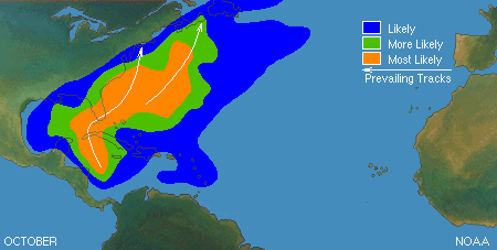
Snowfall Outlook
Main Stormtracks
Raleigh NC Circa 1899

Tallahassee FL Snowball fight circa 1899

There is so much data pointing towards a winter alot like the last two... but possibly colder than the last two. I'm not going to go into a bunch of meteorological terms.... there is just so much overwhelming evidence (Solar activity, Blocking , -NAO/AO, Atlantic sea surface temps, LRC etc etc etc.) to support a cold and snowy winter in the Eastern US. Some of the colder analogs that have been thrown around alot are.... the winter of 1899, 1917 and 1985. Those are some extreme examples of a cold winter in the eastern U.S and lets hope it dont get as cold as 1899..... but those analogs fit the shoe of this winter, I even used 85 in making this outlook.
So what I come up with is a persistant troff over the eastern U.S with a active to very active subtropical jet, with a weak ridge out west. That ridge will be key to just how cold we get. If it gets alot taller out west it could get BRUTALLY cold.
Just know one thing... it will be a cold winter compared to most.
Temp Outlook (The brown represents "near average")
Snowfall Outlook
 |
Main Stormtracks
 |
Raleigh NC Circa 1899
Tallahassee FL Snowball fight circa 1899
Tuesday, September 20, 2011
The Seasons First Upper Level Low
Our first Fall/winter ULL system will become cuttoff and park itself over the Ohio Valley region towards the end of the week. If it were later in the season this would have been a snow maker in the TN valley region, but since it's still early fall and temps are still relatively mild.... we will have to settle for the beneficial rain.

I do expect some exciting weather out of this system somewhere in the eastern US.... but as with all upper level systems, trying to pin that down will drive you nutty. I wouldn't rule out a strong to severe T-storm somewhere in the TN valley but with the packed in cloud cover...this system will be nothing to write home about.
After this stubborn ULL pulls away, the troff over the eastern US will deepen and temps will begin to fall with the NW flow winds becoming dominant. Might have to break out a jacket for the first time this season... as lows could briefly drop down into the high 40's in the east TN valley and low 40's to high 30's in the higher elevated areas... if skies become clear enough for radiational cooling to take place.
Toot
Toot
Saturday, September 17, 2011
A Tale Of The Reoccuring Weather Pattern
While waiting on the Vols game to start... I wanted to talk about Lezaks Recurring Cycle. About two years ago I ran upon this article about a Fall weather pattern regenerating itself several times through the fall and winter. So to see if there was any truth to this I begin watching where and how synoptic scale patterns and storms formed and behaved across the CONUS. Low and behold I started to see what this guy was talking about.
Patterns were forming in the fall and washing theirselves out and then setting up again in a simular if not the same fashion that they set up before. I WAS AMAZED.....Now I consider this a very useful tool in Long Range Forecasting, and I think someone that uses the LRC to forecast the Long Range has a definate edge over somebody who dont.
This is how it works in general...(I wouldnt pay too much attention to the dates, because I think they can vary a couple of weeks in either direction)
http://lrcweather.com/index.php?option=com_content&view=article&id=34:what-is-the-lrc&catid=2:lrc&Itemid=2
If this interests you I suggest you watch it happen right before your very own eyes this coming season.
And one more thing....GO VOLS
Toot

Patterns were forming in the fall and washing theirselves out and then setting up again in a simular if not the same fashion that they set up before. I WAS AMAZED.....Now I consider this a very useful tool in Long Range Forecasting, and I think someone that uses the LRC to forecast the Long Range has a definate edge over somebody who dont.
This is how it works in general...(I wouldnt pay too much attention to the dates, because I think they can vary a couple of weeks in either direction)
1. A Unique wx pattern sets up every Fall around the first of October to the first of November.
2.Longtem longwave troughs and ridges establish theirselves over the northern hemisphere.
3.This pattern cycles and repeats itself over and over again until it slowly weakens and falls apart in the summer.
http://lrcweather.com/index.php?option=com_content&view=article&id=34:what-is-the-lrc&catid=2:lrc&Itemid=2
If this interests you I suggest you watch it happen right before your very own eyes this coming season.
And one more thing....GO VOLS
Toot
Thursday, September 15, 2011
A look into the LONGER range
The long range wx models are liking the idea of a cool and unsettled wx pattern in the extended range. I expect unseasonably cool temps for the remainder of the month, with several bouts of rainy low pressure sytsems. A series of "Lakes Cutter" type storms will push several cold fronts through the state with each one gradually bringing cooler air behind it.
Also the "Lakes Cutter's" should move their stormcenter's southward, closer and closer to us as the jetstream moves south for the fall/winter. As the stormcenter's get closer, the fall severe wx threat will increase due to the system's dynamics getting closer aslo, until finally one really taps into the cold canadian air and ends up changing the pattern into a more winter like climate.
I expect this pattern changing storm sometime in the first half of October, and it could produce some severe weather in the regional area with some possible HIGH elevation snow showers on the back end of the storm. More winter-like conditions will follow... and by Halloween we should be locked into some unseasonably cold temps with near average precipitation.
The current pattern is really more of a LATE fall type pattern than it is an early one, and there is no reason to think that the cycle of (seasonal change before scheduled) will not continue into winter.
I truly believe that this will be one of the coolest fall's that we have experienced in several years.

For those of you that are waiting on my final winter outlook and haven't seen my preliminary winter outlook You can do so by clicking Here...I dont expect major changes to the existing outlook at this time but the New one should be out by October the first.
Toot
Also the "Lakes Cutter's" should move their stormcenter's southward, closer and closer to us as the jetstream moves south for the fall/winter. As the stormcenter's get closer, the fall severe wx threat will increase due to the system's dynamics getting closer aslo, until finally one really taps into the cold canadian air and ends up changing the pattern into a more winter like climate.
I expect this pattern changing storm sometime in the first half of October, and it could produce some severe weather in the regional area with some possible HIGH elevation snow showers on the back end of the storm. More winter-like conditions will follow... and by Halloween we should be locked into some unseasonably cold temps with near average precipitation.
The current pattern is really more of a LATE fall type pattern than it is an early one, and there is no reason to think that the cycle of (seasonal change before scheduled) will not continue into winter.
I truly believe that this will be one of the coolest fall's that we have experienced in several years.
Toot
Cool Start to Fall
A cold front has pushed thru Tennessee and radiational cooling will take place in the clear spots across thestate, while it never really got that warm to start with in the eastern part of the state due to cloud cover. Tomorrow's highs may not reach the 70 degree mark in some spots with the cooler air mass and winds out of the NNW.... with lows tomorrow night flirting with record levels in the eastern part of the state that get lucky enough to get breaks in the clouds. If you stay cloudy tomorrow night expect lows around 50, but if you get clear skies expect lows in the mid to lower 40's.
Summer is basically over and fun times are about to begin. This is my new site where I will post my thoughts as well as my forecasts. I used to post most of them at Tennesseewx.com but that has recently changed. You can come here for reliable info on key changes in the weather... long before they actually change.
I also will be posting about KEY changes in the wx pattern across the US. This will not be a everyday updating Blog ...just the interesting and bigger changes in the WX pattern, allthough I will probably have daily updates here in the winter months.
I encourage everybody to stop by and comment as much as they like as this is a moderator free enviroment, where you can say whatever you wish and I do encourage fiery discussion.
Subscribe to:
Posts (Atom)